
The Synthetic Aperture Interferometric Radiometer (SAIR) Performance Simulator (SAIRPS) is a very versatile software tool developed by DEIMOS Engenharia (Portugal) and the Universitat Politècnica de Catalunya (Spain) for the European Space Agency, using the OpenSF framework. The whole project was led by José Barbosa as Project Manager.
SAIRPS is able to simulate and evaluate the performance of arbitrary SAIRs, with arbitrary receiver and array topologies (1D or 2D) including still or moving antenna elements, or even rotating antennas, in any orbit from a Low Earth Orbit (LEO) to a Geostationary Orbit (GEO).
In the original contract for SAIRPS development, the following modules were implemented, corresponding to the full E2E simulation chain:
Instrument Module: SAIRPS is able to calculate the complex visibility samples of any given instrument configuration. This module is flexible to simulate a generic receiver configuration, include the basic SAIR instrument components and their corresponding errors, include the noise impact induced by instrument components, include physical temperature change impact and include HW non-idealities and uncertainties in the characterization of the instrument.
In addition, the antenna positions and polarization orientations may be varying with time, even during the integration time. In order to achieve this, the receiver has been defined by individual building blocks defined either by their frequency and temperature-dependent S-parameters (to be cascaded) or by the temperature-dependent end-to-end frequency response. Receivers’ noise is computed by their temperature-dependent noise parameters (minimum noise figure, optimum input reflection coefficient, and noise resistance), from which the noise covariance matrix between the incoming and outgoing noises waves is computed. Noise correlation between visibility samples measured by different baselines is also computed. The antenna positions and orientations in the array are also defined as time-dependent variables.
Calibration Module: SAIRPS is able to calculate the calibrated complex visibility samples. This module is able to:
o Select which type of internal calibration is assumed, including the Fringe Washing Function (FWF) at the origin (t=0) and eventually the shape correction (using the three point technique: t=0, ±1/fs), estimation/measurement of the system temperatures, offset errors correction, and receiver quadrature error correction. The following methods are considered:
• 1-0 unbalance corrects for 1 bit/2 level correlators offsets. For arbitrary correlators, the average transfer function for all baselines is computed and then used to pass from digital to “analog-equivalent” cross-correlations,
• Uncorrelated noise injection,
• Two-level correlated noise injection (assuming that a 1:N noise distribution network which properties do not change with the antenna shape, for example), and
• An external point source at a known location.
o Select which type of external calibration is assumed, including Flat Target Response characterization.
Note: Redundant space calibration and phase/amplitude closures were considered, studied and discarded due to the lack of generality.
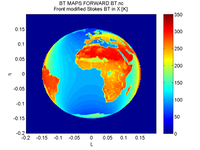
Image Reconstruction Module: SAIRPS is able to produce a reconstructed brightness temperature map from the calibrated visibility samples, as satisfying the requirements. This module includes a basic image reconstruction method (non-uniform FFT) and the G-matrix, Truncated Singular Value Decomposition, Conjugate Gradient and CLEAN methods.
This module includes the particular window function used to tapper the calibrated visibility samples (note: calibrated visibility samples include the complex value of the FWF at the origin), the use of calibrated FWF shape (t=0) for image reconstruction and the use of instrument parameters characterized on ground, such as the antenna patterns.
The software can also be configured for three distinct simulation modes to support different studies’ objectives:
Snapshot Mode – processing of a single brightness temperature snapshot, corresponding to the instrument integration period, to compare against the reference BT maps.
Monte-Carlo Mode – evaluation the instrument performance by analyzing a sequence of consecutive snap-shots for a given constant brightness temperature map. A set of system/instrument random errors can be included in the simulation and the user has the possibility to select which of the components parameters are fixed and which ones are allowed to vary according to its configuration.
Time Evolution Mode – allows the processing of several snapshots over the same region to analyze the impact of time-dependent processes, such as instrument aging, thermal drifts (antennas and receivers physical temperatures), gain stability, or other instrument component model time-dependent drifts.
In a follow-up activity, SAIRPS was upgraded with an new Radiative Transfer Module (RTM) with the main following features:
• Global, high-resolution coverage,
• Fully Polarimetric at the antenna reference frame (at Earth’s reference frame only for the ocean), and
• Frequency range covered from 1 to 100 GHz.
The models and auxiliary data used for the definition of the models come mostly from the following sources:
Land: the Algorithm Theoretical Basis Document (ATBD) for the SMOS Level 2 Soil Moisture Processor Development Continuation Project, which accounts for bare soil, vegetated soil (low vegetation and forests), ice and snow covered soil, inland water bodies and topography. This model includes the Community Microwave Emission Model validated up to 20 GHz developed by the European Centre for Medium-Range Weather Forecasts (ECMWF).
Ocean: the semi-empirical polarimetric model developed by T. Meissner and F. J. Wentz, from 6 to 90 GHz and up to 20 m/s wind speed using WindSat and the SSM/I F13 data.
Atmosphere: this model is at its time the compilation of many models to account for the effects of water vapor, oxygen, rain, water and ice clouds. These models are compiled in the updated revision of the three famous book series “Microwave Remote Sensing: Active and Passive,” edited by Artech House, into the new book.
Auxiliary data files (ADFs) are in an ECMWF Gaussian grid (with configurable resolution), for easier ingestion of external data. Finally, new visualization modes were added: swath projections, alias and Earth/Sky boundary displays, baseline redundancy plots and iso-lines displays.
The project has reached a very successful conclusion, with all objectives achieved.